I can offer a little insight based on what I know. The area we all refer to as Bowater is part of a 1.5 million acre parcel of land the province purchased from the Bowater Mersey Paper Company around ten years ago. It’s officially called the Western Crown Lands. Western Crown Land - Background | novascotia.ca
In 2013 the province held a round of public consultations to gather input on how the people of Nova Scotia wanted the lands utilized. Unfortunately there wasn’t much input from the MTB community, even though mountain biking had been happening in there for a long time. At one time BNS held races in there and some of the old trails and logging roads can be found in Randy’s trail guides (“It’s too cheap not to get” - DH).
There is an existing network of trails on Hiking Trail Rd. called the Old Annapolis Rd trails (NW corner of map). These trails were built by Bowater Mersey in the 1970s. Since the land was sold to the province these trails have fallen into disrepair and have been mostly taken over by the ATV crowd. Which is unfortunate because they pass through some really beautiful terrain. I contacted DoE about these trails last year and found out that there is currently no management plan in place for these trails, and that one of these trails (Rees Lake) passes through the Old Annapolis Rd. Nature Reserve. Nature Reserves are the highest level of protection in the province and the only permitted activity within them is hiking.
There is also the network of unsanctioned trails on the east side of Sandy Lake. These are the trails commonly referred to as Bowater. The majority of these trails are built on Crown Land, although some of them are built on NS Power property (red shaded polygons), but I’ve never heard of anyone having a negative interaction with NS Power staff while riding in there. The rest of trails are built on Crown Land, and Lands and Forests and Dept. of Environment are aware of these trails and have visited them.
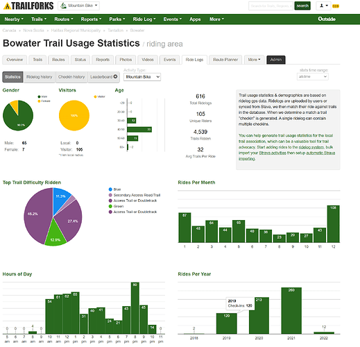
Currently the trails are used by hikers, runners, mountain bikers, and the dirt bike crew. Just after Christmas I ran into a group of birdwatchers on the trails who were there as part of the Christmas bird count. Here’s a screen shot of the trail usage statistics from Trailforks (please note that this only reflects trail users that are syncing data to trail forks, that this is only MTB data, and it only shows when someone has travelled on one of the visible trails):
Some of you may be aware of the proposed Island Lake Wilderness Area. Here’s a link with more info Consultation:Proposed Ingram River Conservation Lands-CLOSED but in a nutshell the local stewardship association has been working with the province the have a portion of the crown land near St. Margarets Bay designated as a Wilderness Area. The province held a period of public consultation last summer and is now working on there next steps. Hopefully we see a new Wilderness Area out there soon.
There is a small group of us local trail users that have been working to form a trail association (Redirecting...) but we need more help. Our goal is to build a sanctioned trail network in the Upper Tantallon area, whether that is in the Wilderness Area or on another piece of land remains to be seen. So far things are looking good, we’ve met with staff from Dept. of Environment Parks and Protected Places and received some great insight from them.
Personally I’d like to see the trails that are on crown land, but not on NS Power property made visible on Trailforks. The proverbial cat is out of the bag, the majority of the hiking, trail running, and mtb communities know of these trails and many have used them. Making the trails visible would make riding there safer, and it would also allow us as a trail association to demonstrate to the land managers (the province) and potential funding sources that there is a demand for a sanctioned single track trail network in the Upper Tantallon/SMB area.
In summary, the land ownership situation out here is complex and the trails are unsanctioned, but so are most of the trails in Halifax and many of the sanctioned trails started out as unsanctioned. Making the trails on crown land visible on Trailforks would aid in demonstrating that there is a demand for a sanctioned trails. If you are out on the trails please be a good trail steward and respect the land. Also, if you are interested in getting involved with our trail association please check out our facebook group.
PS: folks please stop messaging for a trail map lol.


